 02 8319 2266 from Australia
 416-548-4819 from Canada
 04 889 4515 from New Zealand
 646-757-1102 from the USA


 Adlerweg

The Adlerweg: A guide to the trekking in the Austrian Tyrol
 Walking guides - see all our background pages
Introduction
The Adlerweg, which translates to "Eagle's Path" in English, is a long-distance hiking trail that traverses the Austrian Tyrol, which is the large region centred on Innsbruck. The trail was officially opened in 2005 and is named after the golden eagle, as the shape of the route looks like an eagle on a map. The Adlerweg is one of the most renowned long-distance hiking routes in Austria, offering hikers a spectacular journey through the heart of the Austrian Alps.
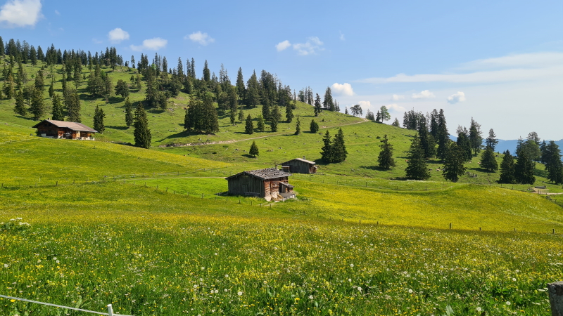
The trail takes hikers through alpine meadows, dense forests, charming villages, and high mountain passes, providing breathtaking panoramic views along the way. Along the route, trekkers encounter traditional Tyrolean architecture, local cuisine, and the warm hospitality of mountain communities.
Best bits
The central section of the Adlerweg through the Karwendel Mountains is one of the most popular and we offer our Adlerweg: Karwendel Mountains trip which covers this area. Starting in Aschau the Adlerweg takes to higher mountains and uses paths of a type familiar to Tour du Mont Blanc trekkers: rocky steps and hard-packed earth. We reach the Erfurterhuette and drop - with optional cable car - to Maurach. Straight away we climb again into the hills in the Karwendel National park, to the Lamsenjochhuette and Karwendel, before dropping back to Scharnitz close to the German baorder. We finish by walking along the Gleirschklamm Gorge and heading back to the Inn Valley. This stretch forms a good short taste of the Adlerweg.
In the East the first 2 stages are popular, with paths traversing around mountains sides in the Wilder Kaiser. Winding paths through forrests characterise these stages. In its Western sections, particularly around Ehrwald and the stage to the Anhalter Huette, limestone mountains (including the Zugspitze, Germany's highest point, shared between the two countries) and pretty lakes dominate the views from the trail. It's an awe-inspiring landscape, and one with a very different flavour to some of our other trips in the Western Alps.

Trips
Alpine Exploratory offers the following holidays based on our Adlerweg research:
Adlerweg
Adlerweg: Karwendel Mountains
Our self-guided holidays give you what you need to complete the route under your own steam. We book your accommodation in a mix of huts and hotels and we give you our detailed routecards, the local maps, and lots of notes.
Research
 Latest research on the Adlerweg by Aline Exploratory's
Pete.
Recces 2023
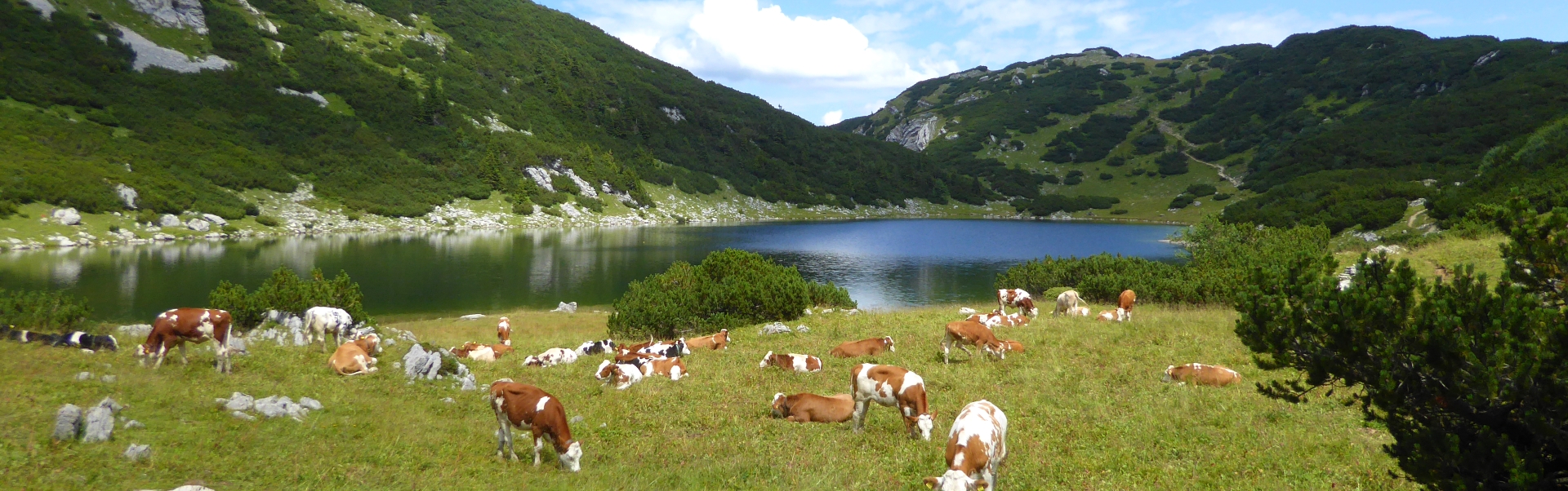
 The Hintersteiner See on stage 3

The Walking
The lie of the land
Austria is relatively low compared to the Western Alps of the Haute Savoie and Savoie regions of France, or the Bernese Oberland and Valais of Switzerland. Peaks reach 3,000m+ insead of 4,000m+. For trekkers, the range is in the 2,000 metres. Practically, the various massifs are divided by deep valleys carrying roads and railways, making getting about quite simple. This is a well-connected area, not too remote.
The Adlerweg takes to a series of massifs, starting with the Wilder Kaiser before Kufstein, passing through the Brandenberg alps to Lake Achen, and then the Karwendel mountains surrounding Innsbruck. An option day hike above Innsburck takes to the Tux Alps. On the Western half our route passes through the Wetterstein Mountains and finall the Lechtaler range to St. Anton. Larger valley towns come every 2-4 days, with huts or smaller villages in between.
What's it like underfoot?
Higher slopes are crossed by classic mountain paths with rock steps and hard-packed ground. Forest paths can be steep, wet and rooty, even muddy. Fast miles go along vehicle tracks, whether in forests or on open moorland. On occasion, grassy open areas make the path on the ground hard to spot. Down in the valley, some country lanes are used to link the hills, giving a view of Austrian agriculture in action. The Adlerweg makes more use of vehicle tracks than our other routes in the Alps.

Is the walking technically difficult?
Our Adlerweg route is a walk, not containing any climbs or via ferrata routes. There is no glacier walking and no rock climbing.
There are however some sections where the path crosses rocky and steep ground including steep scree slopes, plus a few sections with metal cables as handrails over normal Alpine walking terrain. Some stages, particularly those to and from huts, cross open, unforgiving terrain without easy escape routes: these full days of mountain walking call for self-reliance especially in wet weather with bad visibility.

Are the routes obvious?
The paths in the Tyrol are aided by fairly frequent waymarking. This means a mix of red paint flashes on rocks and trees, plus the classic Alpine symbol of white-red-white stripes. Some paths and tracks that have been adopted by the Adlerweg are less well used by general walkers, however, and waymarking can be more sparse.
The presence of a waymark of course only tells the walker that they are on a path - not which path it is! It can help to look for the eagle symbol of the Adlerweg. Most junctions have some form of direction signpost, typically yellow-painted metal finger posts with the Adlerweg symbol appearing against that option. Estimated timings are often given on signposts.
It is essential for all parties in the Tyrol to have at least one competent navigator with a map and compass, for those situations where the route is not marked at a turning or where the clouds have closed in. Our routecards, notes, maps and gpx tracks give you all you need to complete the trek under your own steam.
Is it for me?
The Adlerweg will appeal as a way to see the Tyrol from a long-distance trail; the sense of moving through the country is very strong, especially after the relatively short and intricate first 3 stages. At some points on the route, progress is fast by any Alpine standards as the route adopts wide and smooth tracks that cut through deep valleys, the day to Pinegg being a particular example.

While the bulk of the Adlerweg's distance is on easy terrain, a head for heights is needed on the second day beyond Innsbruck (falling under the Adlerweg West) because of unusually steep and loose scree slopes either side of the pass above the Solsteinhaus. This pass is the Eppzirlerscharte, and it can be missed by retracing steps from the hut and taking a train or buses to the next village, or by taking an alternative trail through the Gleirschklamm gorge.
Well-experienced trekkers with excellent balance on scree, who are also happy to blast along forest tracks, will enjoy all of the Adlerweg, but this adaptability is not for everyone! By missing the Eppzirler Scharte the overall difficulty of the Adlerweg falls to that of the Tour du Mont Blanc roughly, though with longer distances on straightforward tracks than the TMB.
The Adlerweg is a trek open to walkers with solid experience but without need for super-human reserves of energy or agility. The sheer length of the whole route, 15 stages by our approach (or 19 on the extended tour), is quite a feat in itself and it's essential to be used to multi-day trekking in some form. The lifestyle of moving on each day becomes a habit but is not for everyone.
What will the weather be like?
The typical summer's day in the Alps brings hot sun, perhaps with occasional rain or afternoon storms, but in any case paths clear of snow. However, fresh snowfalls occur each summer on a handful of occasions. Most often, these leave a coating of an inch or two on higher passes only, and they disappear in a day or two. However, sometimes the snow stays for longer periods and is deeper. While the Adlerweg should be approached as a summer Alpine trek, with Summer snow unlikely, it is wise to know that snow can fall even in summer.

When to go?
Our Adlerweg season runs from early July to mid-September.
This short season is imposed by the weather: the chance of late-Spring snow patches remaining into early July across the higher passes, and the chance of the weather deteriorating into late September. Because we can't predict the weather for the coming summer, we have to set these dates in advance.

Tyrolean Hospitality
Austria as a country does hospitality exceedingly well. For the quality of the hotels it is perhaps our favourite in the Alps. Standards are reliably good, the emphasis being on the ease with which a traveler can gain what they need; plentiful and tasty food, and a comfortable bed. The service is carried out in a low-key way - all this is merely the norm in this very civilised country.
In the valleys, this culture translates to the typical Austrian hotel experience of a good set dinner often being included; on the Adlerweg we try to follow this style, resulting in more dinners included on our Adlerweg treks than some of our other Alpine routes. We love the family-run hotels in towns including Maurach, Hall, Innsbruck, Weidach and Ehrwald. In Steeg as well, expect a real Austrian Tyrolean experience with staff in traditional uniforms - the dirndl of Tyrol and Bavaria - and lots of wood and Alpine themes.

The Austrian huts follow a common Alpine pattern, built and run to cater for big numbers of trekkers in a practical and comfortable way. Austrian huts are some of our favourites, warm and welcoming. A few huts are run by the DAV, the German Alpine Club, as outposts in bigger hills than many German regions can boast. Dormitories are common, sometimes private rooms as well. (We will advise on the sleeping arrangements according to your particular schedule.) Showers are available, often with a token system for a small extra payment to the warden. For food, expect a simple menu of large portions and plenty of cake, beer, coffee and soft drinks. Our standard Adlerweg trip makes use of 5 welcoming Austrian huts.

Passing through Innsbruck so many times, indeed making it a base, has given us a choice of hotels to draw from and here more than other places on the Adlerweg we have the option of modern hotels. The emphasis on business travel doesn't detract from the style; again Austria handles this distinction with its customary poise, and the decoration and thought given to breakfasts are very high.

The Adlerweg in context
The Adlerweg compared to treks in the UK
If familiar with the Coast to Coast, the Adlerweg has broad similarities in its generally flat and smooth terrain punctuated - as in the Lake District sections of the CTC - with short sections of rocky or unclear paths. Added to this, the screes slopes either side of the Eppzirlerscharte are above the level of anything on the CTC. This makes it hard to gauge how the Adlerweg will feel. To be ready for anything is ideal, of course, as in UK hillwalking, but also to be happy with long forest sections.
The Adlerweg compared to other Alpine trips
The Tour du Mont Blanc is the obvious comparison, with much of the Adlerweg being at a lower level of difficulty underfoot. This is due to the Adlerweg's long miles on wide smooth tracks. The section through the Karwendel is more mountainous and fairly similar to the TMB. Another comparable hike is the Via Alpina which crosses Switzerland from East to West. Overall the Adlerweg is a little easier with slightly shorter days. The Walker's Haute Route is substantially harder (on of the hardest trips that we organise).
City breaks after trekking
Combine your Adlerweg trip with a city break:
 Munich in Germany
Vienna in Austria
Innsbruck in Austria
Zurich in Switzerland
City breaks after hiking in the Alps
Hike the Adlerweg with Alpine Exploratory
Alpine Exploratory offers two self-guided options on the Adlerweg: our main trip and our Adlerweg: Karwendel mountains. We're also pleased to book shorter or longer sub-sections of the routes according to your available dates... and a weekend trip can work with care. Please contact us to discuss options. We like to recommend sections of 3 or 4 days; these work nicely.
Adlerweg
Adlerweg: Karwendel Mountains
Our self-guided holidays give you what you need to complete the route under your own steam. We book your accommodation in a mix of huts and hotels and we give you our detailed routecards, the local maps, and lots of notes. Our guided trips are similar but give you the benefit of an Alpine Exploratory leader to show the way.
Please ask us any time for more details. Please feel free to describe your walking experience and preferences, and we'll suggest which trek you might enjoy most.
Keep up with us on Facebook, Instagram, and our Blog for photos and updates from our own travels and clients' trips.


  Adlerweg enquiry form
|


 Alpine Exploratory
 +44 (0)131 214 1144
