 02 8319 2266 from Australia
 416-548-4819 from Canada
 04 889 4515 from New Zealand
 646-757-1102 from the USA


 Tour of the Vanoise
Tour of the Vanoise: A guide to the trek
 Walking guides - see all our background pages
Bare facts
The Vanoise National Park - the first National Park to be established in France - sits in the South East of the country and borders Northern Italy. With over 300 peaks above 3000m, the scenery is bold and encompasses glaciers, rolling grassy meadows and glacial lakes, a true Alpine gem yet still relatively unknown. Our Tour of The Vanoise is mostly a hut-to-hut trek, staying high with unrivalled views of the various massifs in the region, including the Mont Blanc massif. We visit tiny hamlets and pass isolated farmsteads, as well as dropping into the buzzing resort of Val d’Isere and the quintessential Alpine village of Pralognan-la-Vanoise.
Best bits
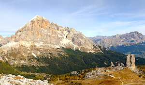
This is a tough one! The boldest stages of the Tour of the Vanoise cross the mountains from Val d‘Isère and Tignes towards Pralognan, with stage 8 and 9 often being a favourite as you walk into the heart of the Vanoise National Park. Here is the Lac des Vaches (cows), one of the better-known spots in the whole of the Alps with stepping stones over the water and peaks above. We also love the hut-to-hut stages between the charming Refuge Plan Sec to Refuge Plan Lac offering spectacular glacier views throughout the two days.
Trips
Alpine Exploratory offers the following holidays based on our Vanoise research:
Tour of the Vanoise
Research
 Alpine Exploratory's research on the Tour of the Vanoise will be led by Nicky Mount in July
Recces 2021
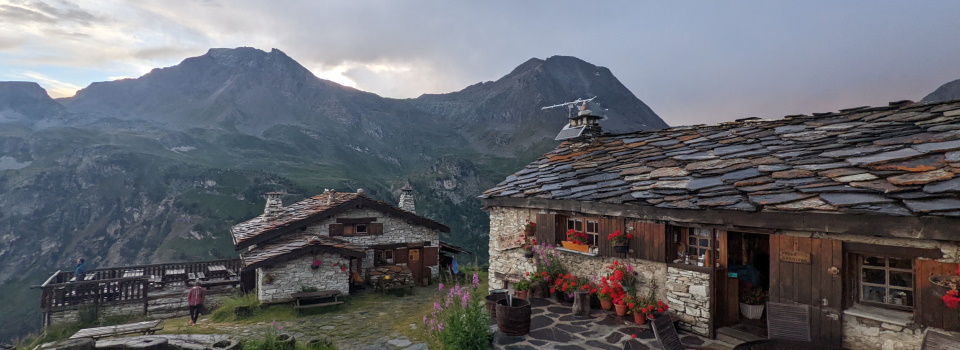
 Refuge Plan Sec on Stage 3 of the Tour of the Vanoise

Is it for me?
Distances Our classic 11-stage trip features days mostly between 8 and 10 miles, with the longest day being 12.5 miles. This tour will suit strong mountain walkers, who are fit and happy to walk between 3 to 7 hours per day. There is a considerable amount of ascent and descent on this route, which must not be underestimated particularly when carrying a rucksack. Stage 1 for example, is a half day of solidly uphill, hence why we keep it short as way of an introduction!
Underfoot The Tour of the Vanoise features a range of narrow grassy mountain path as well as some wider tracks and steep, loose and rocky paths usually around the cols. The terrain is similar to many treks across the Alps, such as the Tour du Mont Blanc or Walker’s Haute Route. There is one memorable section of stepping stones across a small lake (Lac des Vaches), on stage 9. There are also short sections of path with chains attached to the rock to aid passage, often with a steep drop to one side.
Navigation The route follows mostly clear paths and tracks, linking sections of the GR5 and GR55 long distance routes. There are waymarks and cairns to guide the way too, and often signposts which usually give an indication of times to the next hut or village. Being a more isolated trek, in wilder surroundings for sections of the trail, it is important that at least one member of the group is a confident navigator, particularly in case of poor weather.
Weather Weather in the high mountains is typically a mix of hot sunshine, cold nights, cooler rainy days, and everything in between! Prepare for the unexpected and always go equipped with wet weather gear, along with sun hat and sun cream for those warmer days. Snow can be a feature at any point during the Summer months, but typically will not last long and will be isolated to the higher cols.
When to go?
Our season on the Tour of the Vanoise follows our normal Alpine walking season of mid-July to mid-September. Typically this lets us stick to high Summer weather, avoiding the late snow-melt that is possible some years and hard to predict. We recommend booking your trip in July or August as September sees a quieter atmosphere in the towns as many restaurants start in close for the shoulder season.

Where to stay
A joy of the Vanoise is the series of huts in which we are able to stay. These are French huts away from the hustle and bustle of the Tour du Mont Blanc, which allows for a more gentle and homely style of welcome and food. Pastoral and mountainous France means simple pleasures of wooden building and furnishing, then combinations of eggs, cheese, ham and potatoes (think tartiflette and reblochon cheese).
Initially the huts run above the Maurienne valley as we traverse high above Modane. The trail crosses the Col de l’Iseran and we drop to Val d’Isère for a night. Here the Winter trade is strong with skiers and it means several smart hotels for Summer use; Val d'Isere will be an enjoyable night. In a lower-key way, Pralognan is good for hotels and restaurants, and then we cross the final col near which is the modern Refuge de Péclet-Polset. This pattern of huts and hotels gives a good pattern to our route.
City breaks after trekking
Our Tour of the Vanoise holidays come with notes on the following cities, in your info pack:
 Geneva in Switzerland
Grenoble in France
City breaks after trekking

The Route
Here's a brief guide to the places and experiences on the TVA, on our normal 11-stage schedule.
Stage One
The first day starts in the French town of Modane. Find your mountain legs with a sustained climb out of the valley and into the mountains proper. The day is short so you have plenty of time to relax and enjoy the walking. Most of the ascent is in trees; however, your hard work is rewarded by the views which open up as you ascend. Once at the top, there is a real mountain feel and a fantastic taste of what’s to come!
Stage Two
A climb through trees leads to a traverse across open hillsides, and the best distant views so far. Having sighted the day’s destination across the valley, the second half of the day involves a circuit high above two lakes to reach the hut. Enjoy the views from the Refuge de Plan Sec at the end of the day, perched high on the hillside.
Stage Three
A day of gentle ups and downs, and long traverses across the hillsides. Today’s stage makes significant progress around the National Park with views ahead, behind, above, below and out across the valley. The second half of the day sees rougher country, until the final combe with the Refuge at the far side. In hot weather you may be treated to waterfalls above the streams before arriving at the refuge for the night.
Stage Four
Another day of stupendous views, possibly better than the previous stage. Rough and rocky terrain gives way to grassier combes and glacial valleys. The day’s destination can be seen for much of the first half, but the route takes a long loop around the head of the Doron gorge.
Stage Five
Firstly, the route completes the foray into the mountains around the Doron gorge, with fantastic views back to the previous stages. After Crête de la Turra, we rejoin the l’Arc valley and continue East on a high-level traverse across the hillside. Another day of good tracks and paths, and ever-changing vistas.
Stage Six
This stage gives a change of scene, as the route quickly drops to the River Arc for the first time since Modane. There follows an easy stroll along the valley bottom to the accompaniment of birdsong, waterfalls and just the occasional traffic. A day to encounter a bit more of the Alpine civilization than on the previous stages, and possibly some mid-walk refreshments in the charming village of Bessans.
Stage Seven
An up and down day, going from the valley of the Arc, over the highest paved col in the Alps (Col de l'Iseran) down into the valley of the Isère: a change of valley and a change of character. The climb up is steep in places, but the descent is mostly well-graded. Enjoy the variety, and a night in the largest town to be visited by the Tour of the Vanoise, famous ski resort Val d'Isere.
Stage Eight
A day of stark contrasts. This stage starts with the modern architecture of the ski centres of Val d’Isère, Tignes and Val Claret, and finishes in the wild beauty of the Vallon de la Leisse where the refuge’s buildings are the only ones within sight. Along the way are two places from which it is possible to see the Mont Blanc massif.
Stage Nine
A day spent going from wild mountain scenery to a traditional small town typical of the Vanoise. The mountain views around the Col de la Vanoise are superb and it is a popular place to spot Chamois and Ibex, keep you eyes pealed! After a long descent, arrive at the genteel village of Pralognan which has all that's required without the modern architecture of the previous stage. We love Pralognan!
Stage Ten
A relatively relaxed day today despite the height gain as most of the day is spent on good tracks and paths. The route traverses pretty countryside before climbing steadily up-valley and into the mountains with Pointe de l’Echelle in view ahead. The route feels wilder as you continue to climb to your home for the night; the futuristic refuge of Péclet-Polset.
Stage Eleven
This stage traverses the Col de Chavière, the last and highest col on the Tour of the Vanoise, and also the highest col crossed by any of the GR routes. And a grand setting it is. The route up is over loose steep scree, but once up, the downhill is on good paths. Once beyond the col, it is downhill almost all the way to Modane. Congratulations on the Tour of the Vanoise!

The TVA in context
The TVA compared to the Tour du Mont Blanc
Compared to the Tour du Mont Blanc, also based in France at least at start and end, the Vanoise tour is more of a challenge. The stage lengths and ascents are roughly in the same range, and overall the tour is of similar length, but what makes the Vanoise area harder is the wilderness and drama of the settings. We are often further from civilisation. This might not matter on a given trip, but if it did matter then it would! Perhaps the Vanoise calls for greater experience and preparedness. Practically, there is greater use of huts on the Vanoise tour, and walkers might find fewer other people around them. Still, the general culture and the systems of the huts are the same enjoyable mix as on the French days of the TMB and we hope the Vanoise will appeal to TMB hikers who’d like to see more of the French Alps.
Comparing the TVA to our 5 big Alpine treks
The Haute Route is substantially the toughest, suitable only for trekkers with particularly solid experience, balance and fitness.
The Via Alpina includes three rocky cols that approach the Haute Route's level of challenge, though the route as a whole is more forgiving. The same applies to the Adlerweg but in its case one col (the Eppzirlerscharte) stands above the rest as very difficult, and it can be skipped by descending and taking the train. The Adlerweg is notable for some long days on wide tracks.
The AV1 is more consistent in its difficulty but is especially demanding of good balance, with steep, rocky and wild situations calling for mountain experience.
The TMB is a superb all-rounder that mixes tough, solid mountain days with gentler ones, allowing trekkers to sample the harder terrain as at the Fenetre d'Arpette (a variant, shared with the Haute Route) while not requiring any extremes.
It's worth noting that each trek has different possible schedules, governing the physical difficulty, and on many days different variants affect the terrain difficulty.
Below we compare the stats one by one:

Two weeks of Alpine trekking in a circuit from the Chamonix valley

Distance: About 180km or 110 miles
typically done over 11 stages
Ascent: About 10,700m (35,000ft)
Highest point: Just over 2,500m (8,200ft) and the route crosses several passes around 2,500m
Terrain: Good mountain paths, rockier and looser sections, cables and ladders, tracks and country lanes
Accommodation: Hotels, huts and auberges in a varied mix
Season: Early July to mid-September
A week and a half of Alpine trekking from Dobbiaco to Belluno
Distance: About 120km or 75 miles
typically done over 10 stages
Ascent: About 6,650m (22,000ft)
Highest point: Just over 2,750m (9,000ft) and the route spends much time over 2,000m
Terrain: Good mountain paths, some rockier and looser sections, tracks and country lanes
Accommodation: Mostly mountain huts, plus hotels at start and finish
Season: Mid-July to mid-September
Two weeks of Alpine trekking from Chamonix to Zermatt

Distance: About 200km or 125 miles
typically done over 14 stages
Ascent: About 12,900m (42,300ft)
Highest point: Just under 3,000m (9,800ft) and the route crosses several passes over 2,900m
Terrain: Good mountain paths, rocky and loose sections, wild remote cols, cables/ladders, tracks and lanes
Accommodation: Hotels, huts and auberges in a varied mix
Season: Mid-July to mid-September
Three weeks of Alpine trekking in the Tyrol from St. Johann to St. Anton

Distance: About 387km or 242 miles
typically done over 19 stages
Ascent: About 14,400m (47,240ft)
Highest point: Just over 2,250m (7,380ft) and the route crosses a number of cols above 2,000m
Terrain: Good mountain paths, forest tracks, some rockier and looser sections, tracks and country lanes
Accommodation: Hotels and huts in a varied mix
Season: Early July to mid-September
Three weeks of Alpine trekking across the width of Switzerland

Distance: About 349km or 219 miles
typically done over 18 stages
Ascent: About 19,960m (65,485ft)
Highest point: Just over 2,800m (9,180ft) and the route crosses three passes above 2,300m
Terrain: Good mountain paths, rocky and steep cols, grassy cols, tracks and country lanes
Accommodation: Good hotels and no huts (but can be added)
Season: Mid-July to mid-September
A week and a half of Alpine trekking in the Vanoise National Park

Distance: About 160km or 100 miles
typically done over 11 stages
Ascent: About 8,480m (27,800ft)
Highest point: Just under 2,800m (9,180ft) and the route crosses a number of passes above 2,500m
Terrain: Solid mountain paths, some steep and rocky sections, hillside paths and tracks
Accommodation: Hotels and huts in a varied mix
Season: Mid-July to mid-September
Hike the Tour of the Vanoise with Alpine Exploratory
Alpine Exploratory offers a self-guided trip of 11 stages for the TVA. For shorter trips, with the remainder left for another holiday, we recommend the Northern section over 4 or 5 days, starting in Val d'Isere and walking via Pralognan to Modane. The Southern section of the trail is then 7 days from Modane to Val d'Isere. Please ask us for more details.
Our self-guided holidays give you what you need to complete the route under your own steam. We book your accommodation in a mix of rustic huts and comfy hotels and we give you our detailed routecards, the local maps, and lots of notes. Importantly we will advise on the ideal schedule and accommodation to suit your approach to the TVA. Our guided trips are similar but give you the benefit of an Alpine Exploratory leader to show the way.
Please ask us any time for more details. Please feel free to describe your walking experience and preferences, and we'll suggest which trek you might enjoy most.
Keep up with us on Facebook, Instagram, and our Blog for photos and updates from our own travels and clients' trips.


  Tour of the Vanoise enquiry form
|


 Alpine Exploratory
 +44 (0)131 214 1144
